
Mapping Intro
A Guide to Trench Maps
The four years of relatively static warfare in Belgium and France, from late 1914 to the end of the First World War, entailed the excavation of thousands of miles of trenches and static fortifications. The record of the development of these static defence lines was maintained in the British sectors of the Western Front by the Geographical Section of the General Staff (GSGS) from topographical survey detail and aerial photography provided by the Royal Engineers and Royal Flying Corps (later in 1918 the RAF) respectively.
"A map is a weapon” — Lt. Col. E.M. Jack, Royal Engineers, Maps GHQ, BEF.
When the BEF went to France and Belgium in August 1914 they took with them tactical maps in the scale of 1:80,000 scale for France (GSGS 2526) and 1:100,000 for Belgium (GSGS 2364). These were perfect for a war of movement, as had been encountered previously with earlier military campaigns, but when war became static from September 1914 there was a need for larger scale maps that had more detail of the battle areas. The maps were enlarged to 1:40,000 scale and then to 1:20,000 as trench warfare was established.
The original 1:80,000 maps, surveyed almost a hundred years prior, suffered from inaccuracies that were accentuated by the enlargements. There was therefore a need to conduct new surveys which were started in January 1915 by the Royal Engineers. This survey produced a new series of 1:20,000 scale maps (GSGS 2742). These early war maps did not show trenches until the summer of 1915 as their primary use was by the artillery. That said, hand-drawn 1:5,000 scale trench maps had been produced in small numbers in early 1915 and used in operations as the Battle of Neuve Chapelle in March 1915 and Aubers Ridge in May. Whilst these sketch maps were useful, they were also inaccurate, which led to a new regular series of 1:10,000 scale maps (GSGS 3062) being produced from June 1915 to cover the whole British front. These maps would show the trench outlines but little else. It took until August 1915 for the first trench maps to be produced, which were used for the Battle of Loos in September 1915. Whilst these were still inaccurate they provided the base maps for the British areas of the Western Front and allowed a new set of 1:20,000 scale maps to be produced.
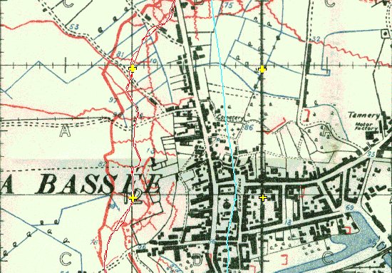
An example below of a 1915 1:10,000 map of La Bassee (Map is 10-36C(44A)NW1-Prov2A-051115-LaBassee) showing the turquoise GPS track line as we follow the modern day road. Whilst this is built over the original pre-war road, in places it can be up to 100 metres out. Primarily used in 1915 by the artillery, the maps can help you understand why bombardments were not always accurate.
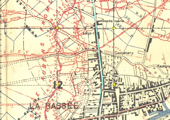
Compare the above image with a 1918 map of La Bassee (10-36C(44A)NW1-10B-240518-LaBassee), the added accuracy is amazing and the turquoise GPS track line follows the road almost perfectly. No wonder accuracy of bombardments improved as map quality developed.
In February 1916 specialist Royal Engineer Field Survey Companies had been formed which had the skills and techniques necessary to vastly improve map accuracy which led to trench details being marked on the smaller scale 1:20,000 maps. By the time of the Battle of the Somme in July 1916, the maps were of a high standard and accurate for infantry and gunners alike. By late 1917 the production of trench maps had reached its heights with a variety of editions being produced and corrections to these being printed within days of them being noted.
Into 1918 you start to see maps with not only British and German trenches, but knocked out tanks, craters, shell holes, felled trees, dugouts etc. You also see a change in the trench colours on some maps that see's the British swap the colours to come into line with French practice (British trenches become red, and German are blue). To add even more confusion, some trench maps were printed with all the trenches of the same colour. A base map usually had an edition number followed by a letter, so a map marked 6C had an edition 6 base map and the trench over print of edition C. This system was not strictly adhered to, since sometimes, two maps with the same number and letter can be found but with different detail and different dates. On many of the maps, the words "Trenches corrected to" are followed by either a single date or a separate date for British and German trenches. By August 1918 however, the beginning of the last 100 days, when open warfare becomes dominant once again, its becomes impossible to keep up with the changes as the British advance is so rapid. The 1:10,000 scale maps are then discarded in favour of the 1:20,000 and 1:40,000 scale maps once again, with few, if any trenches being marked.
Trench Map Squares & Keys
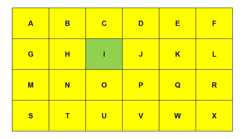
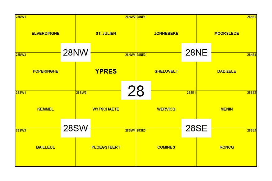
The initial key to the trench maps was detailed by GSGS on a series of 1:40,000 scale maps, each covering a rectangular area of part of the Western Front measuring 36,000 yards by 24,000 yards (244 square miles) and overlaid with a grid of twenty-four squares annotated A to X each measuring 6,000 yards by 6,000 yards typically as below:
Map sheet 28 (244 square miles)
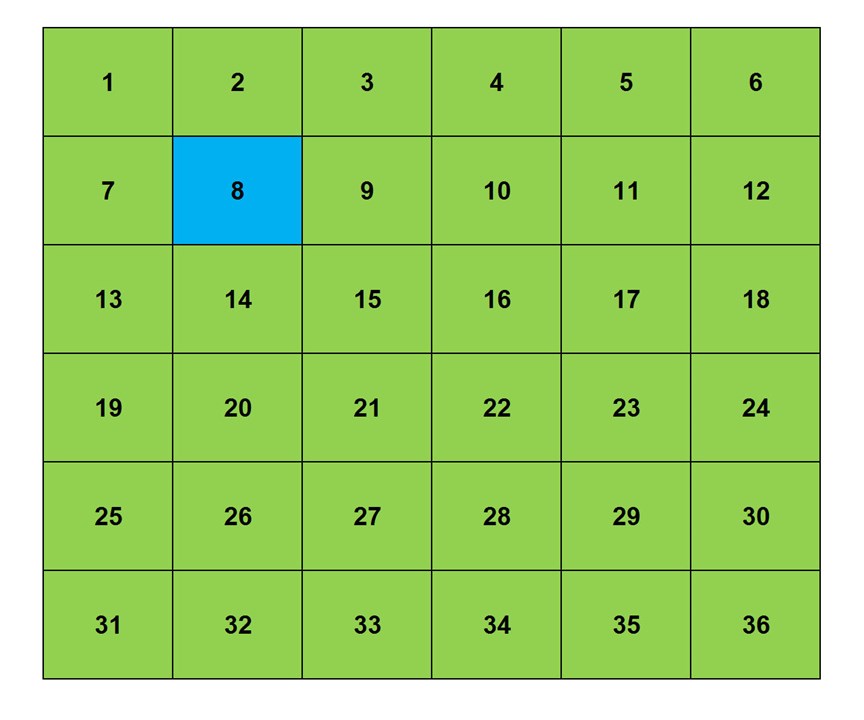
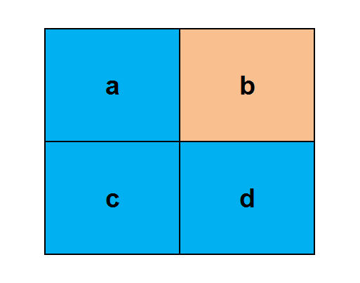
The capital-lettered square is further divided into thirty-six (occasionally thirty) smaller squares each measuring 1,000 yards by 1,000 yards and numbered 1 to 36:
28I (6,000 yards square)
The 1:40,000 scale maps were quartered (61 square miles each) and each quarter identified from the centre of the map as NW, NE, SW and SE. Map sheets were produced from these quarters at 1:20,000 scale primarily for use by the artillery. A further series of 1:10,000 larger scale maps were produced from quartering the 1:20,000 scale maps and numbered 1 to 4 and named after the area they cover, principally for use by the infantry.
Map Sheet 28
To identify a map reference the 1000 yard square was further divided into four 500 yard squares lettered a to d:
28I.8 (1,000 yards square)
On 1:10,000 scale maps, the 500 yard squares are divided into easting and northing divisions in tenths:
28I.8b (500 yards square)
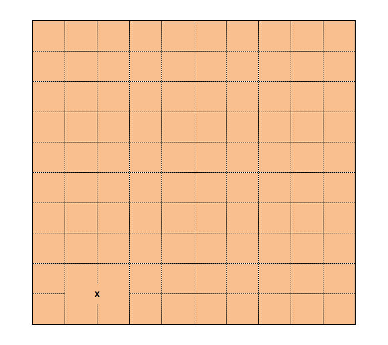
Eastings, left to right, are quoted first, followed by northings, bottom to top. Therefore, the map reference for the indicated point X is recorded as 28I.8b.2.1 (the position of the Menin Gate)
Please note that the yardage grids detailed above are arbitrary and overlaid over a metric topographical map and are not continuous. It is, therefore, not possible to produce a simple mathematical transform to consistently convert First World War map references into a modern lat/ long or WGS 84 references from the grids.
References
1. Textbook of Topographical and Geographical Surveying by Colonel C.F Close, C.M.G, R.E. Director General of the Ordnance Survey.
2. Report on Survey on the Western front, 1914–1918 (Published 1920) HMSO - by Colonel E.M. Jack.
3. Artillery's Astrologers, A History of British Survey and Mapping on the Western Front 1914-1918 (Published 1999) - by Peter Chasseaud.
4. Topography of Armageddon - A British Trench Map Atlas of the Western Front (Published 1991) - by Peter Chasseaud.
5. Rats Alley: Trench Names of the Western Front, 1914-1918 (2017) by Peter Chasseaud.
Find out more on our GPS/mobile page or see our preloaded tablet option LinesMan2Go

PC/Mac and Mobile software powered by