
About Us
About Us
Great War Digital is a UK based company whose purpose is to conserve historical maps and documents by digital scanning and then making the scans available on digital media such as DVD/USB. The original Directors of Great War Digital Ltd were Guy Smith and Jerry Whitehead, both of whom have been instrumental in the development of LinesMan. The company is now run by Stephen Chambers who will continue the development and growth of Great War Digital into a post centenary era.
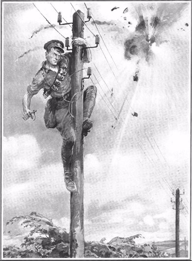
Image: With the Signal Service in France: Repairing a broken telephone wire was known as "treeing a linesman". Not an uncommon sight on the Western Front. Drawing by Philip Dad. Published in The Sphere, September 1915.
 Guy Smith was technical director behind the IWM CD Rom in 2001. That CD was ground breaking, in as much as it brought a hitherto unseen archive of 175 trench maps to the public gaze. He has subsequently put considerable thought and research into producing a more comprehensive format for presenting trench maps, both as an archival tool and navigation companion for battlefield research, which can be used by both amateur enthusiast and professional historian/archaeologist. Guy is a member of the Western Front Association.
For many years Jerry Whitehead had run Kingshead Adventures, a UK based battlefield Tour Company offering a unique bespoke tour service for individuals, couples, families or small parties of friends, who prefer to travel independently rather than as part of a large group. Over more recent years Jerry has been working alongside Guy to develop LinesMan and to test trial versions in the field. The excellent results produced have been the catalyst to developing the final product version. Jerry is a member of the Western Front Association and also a Map Associate at the Imperial War Museum in London.
In conjunction with the above, Stephen Chambers has joined the board in 2018, and is now Director of Great War Digital. Steve is one of the leading military historians on the Gallipoli campaign. Even though this is his prime passion, he also has in-depth knowledge of many British military campaigns and battles that include the Zulu and Anglo-Boer Wars, First World War and the Second World War. Steve is a freelance battlefield guide, author and researcher with a great interest in military mapping. Steve is a Trustee of the Gallipoli Association and a member of the Western Front Association and Orders and Medals Research Society. He is also an accredited member of the Guild of Battlefield Guides, Badge No.75, and a qualified IT Professional having worked in the computing industry for over 25 years.
Many hurdles have been overcome since beginning this project, not least of which has been having enough scanned maps to make it all possible. What started as a hobby has snowballed to the point that we now hold a personal archive of over 1100 maps, which have formed the basis of the system. These have been topped up with maps from numerous private collections, (with the help of some very kind people) and, additionally, we have been to some major institutions to source some of the 'Secret' maps that are not generally in private hands. As far as we are aware, this is the first ever application of 'Historical' data into a Global Positioning System (GPS), and the combined package has been very rewarding to bring to this level. People's generosity, and trust, has been astounding. On several occasions, we have walked away with thousands of pounds worth of maps to be scanned, with almost no exchange of addresses. In some ways that spirit encapsulates quite why this conflict was fought, and to those people (listed below), we are indebted, as, without their goodwill, this project would not be here in its present form.
In the intermediate years, development of static and mobile computer and storage media devices technology has enabled us now to bring a huge range of maps, and new software has allowed an incredible step change in what can be done with them and how they are presented.
Credits
Great War Digital Ltd acknowledge with thanks the following contributors:
Jerry Whitehead (Maps, Sponsor, and Commercial Direction)
Guy Smith (Maps and Technical Direction)
Jason Spiller (Cartographic Consultant)
Private individuals and further map contributors, Nigel Parker, Collin Roberts, Trevor Pidgeon, David Fillsel, Duncan Skillen, Geoff Bridger, Julian Sykes, Andy Tonge, Stephen Chambers and Richard Dunning.
Institutions that have provided further maps include: The Imperial War Museum, The National Archives, the Royal Geographical Society and the Western Front Association.
Rights
Purchase of a LinesMan software product and licence enables the user to load the software onto and use it on any three fixed or mobile devices generally described as desktop PC, smartphone, tablet or dedicated global positioning device.
Contact Us
Great War Digital Ltd
sales@greatwardigital.com