
Troubleshooting
Our Trench Map product is a companion product that runs on the Memory-Map platform. This Platform is tried and tested by many thousands of existing customers for other Sat Nav products. It is commonly used in aeroplanes with Air Charts for private flying, and is correspondingly reliable.
Here are a few common questions, which may arise through unfamiliarity with the software.
Q: I seem to have lost the ability to see the trench overlays
A: If the install has worked fine and the overlays did originally install but have subsequently disappeared and cannot be returned, it is probable that you have clicked the OVERLAY > DELETE ALL button. This will delete all trench overlays, along with any other user overlays. The trench overlay is loaded into your user data file and will be mass deleted with this menu option.
Any overlays which you add yourself on screen need to be removed individually by a right click and delete option.
Solution: In order to fix this problem, simply re-install the LinesMan disc (no need to re-install the Memory-Map disc and no need to re-register license etc). The trench overlays will reappear.
Q: After installing my product, the trench maps appear horribly pixelated, and unusable.
A: You have not completed the instructions for ‘Registering’ and ‘Activating’ the product on line. Please refer to the Instruction leaflet that is included in the product.
Q: I press the 3D Map button, and my 3D views do not work.
A: The common reason for this is that memory map does not have an appropriate Height Digital Terrain Model loaded for the area you are viewing. Press the Data button on the toolbar, and hover over the area. It should give a value in the 'elevation' field that is displayed.
If it does not, or it is zero, first now check that the area you are viewing is within the geographic area of the Nord Picardie-Champagne Ardennes, Memory-Map product. Height data is only available within these regions.
The simple fix, is to Right Mouse click, and choose the 'Maps at Cursor' option. Open an IGN Aerial Photo of the area, and let it load. This will also load the height data.
Now repeat the process and load the Trench Map of interest. The 3D Map button should now produce superb 3D views.
Please note that 3D views do not function for Belgium because, as yet, there is no height data available on a single PC mass application license basis.
If the above solution fails, the fault could lie with the version of DirectX that you have on your machine. Or it could be that your graphics card on your computer is not up to it. We would recommend in the first instance checking the Memory-Map web site for possible solutions and compatibility, see: https://memory-map.com/
Q: I have installed all the maps currently available with your LinesMan 10 and LinesMan 20 products and have refreshed the 'Map List' to include all the map files. Yet, I find if I 'right-click' the mouse and select 'Maps at Cursor' not all the maps apparently available are listed for display.
A: When all maps now available with LinesMan for the Western Front are installed and the 'Map List' is refreshed to include all the map files the choice of maps at any point is now so extensive that at some places the mouse 'right-click'>Maps at Cursor feature may not be able to list all the maps currently available. To ensure you can review all maps at a particular position please 'right-click' your mouse and select Maps at Cursor>Map List at Cursor whereupon you may select a map from all those available to display.
The following is not a fault, but an explaination of an apparent error.
Q: When using my GPS with Trench Maps, my GPS marker sometimes leaves the road...Why
A: It must be remembered that this map archive is 90 years old, and a lot has changed in that time. Many of the roads on the maps were quite simply 'obliterated', and only relaid after the war. There are no guarantees that they were re-laid in exactly the same place. In these circumstances, both the trench Maps and the GPS returns are correct. The GPS is locating where you are on the new one and not the old one marked on the map. If you want to find where the old one was, simply walk until the marker moves over the map marked road.
Another issue might be the accuracy of the maps themselves. They were hastily prepared in wartime, many areas mapped were behind enemy lines, and it was not possible to direct survey. The maps were continually worked on and improved from aerial photos as the war progressed. We have found that later map editions are generally far more accurate than early ones.
The maps themselves and the grid squares were also revised with time. Here is an extreme example that we discovered while building this product:
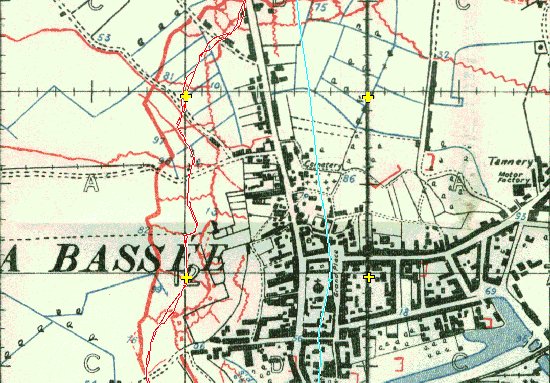
La Bassee 1915...Above.. The grid is right, the map is not. (this is a rare case, very few maps have problems such as this) (Map is 10-36C(44A)NW1-Prov2A-051115-LaBassee)
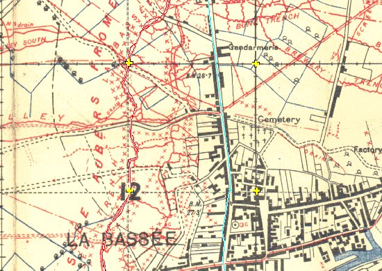
La Bassee 1918...Above.. (Map is 10-36C(44A)NW1-10B-240518-LaBassee)
You can see clearly, that the Grid squares, marked with the yellow crosses, remains correct, but the map is actually drawn in a different location beneath it. This error was obviously revised, as the later 1918 edition matches exactly with the Turquoise GPS track shown.
The maps have had to be correctly geo-referenced with relation to the grid, and not the features, and we have not attempted to correct the original WW1 errors, but we have concluded that often, certainly the 1915 maps can only be used for reference and historical interest, and not for accurate GPS use. In general, 1916 maps and onwards are much better.
As can be seen above, the 1918 version of the map, is very accurate indeed.
Another possible source of apparent error, is that many of the roads in 1914-18 were single track. With the modernisation of France and Belgium into proper double width roads, they have all been widened. On which side, we do not know, but it does account for a slight apparent error.
Should you encounter any difficulty with the software, there are two courses of action. If you believe the problem lies with Memory Map, they have an excellent web site see: https://memory-map.com/ and an excellent support team.
If you feel the issue lies with the Trench Map product, then feel free to contact us for advice.
Q: I have installed all the maps currently available with your LinesMan 10 and LinesMan 20 products and have refreshed the ‘Map List' to include all the map files. Yet, I find if I ‘right-click' the mouse and select ‘Maps at Cursor' not all the maps apparently available are listed for display.
A: When all maps now available with LinesMan for the Western Front are installed and the ‘Map List' is refreshed to include all the map files the choice of maps at any point is now so extensive that at some places the mouse ‘right-click'>Maps at Cursor feature may not be able to list all the maps currently available. To ensure you can review all maps at a particular position please ‘right-click' your mouse and select Maps at Cursor>Map List at Cursor whereupon you may select a map from all those available to display.
Q: Search is not working?
A. When researching a particular place it may be easier to use the search index. This index is only available when the LinesMan2Go Map Index is displayed. Select Maps and then the LinesMan2Go Map Index from the Maps At This Location list. Then select Search and touch the screen at Place Name to display the keyboard and start typing in your place of interest and as you type place name options will appear in the box below. Selecting a name listed will take you to a trench map containing that name. Again you may select Maps to enable you to select an alternative map at a date more appropriate to your research.
If your name search does not produce any results you may have to change your search, for example, find a town or village close to your point of interest and search this.
Note: The search index does not include trench names – a gazetteer such as RATS ALLEY by Peter Chasseaud will assist in the location of named trenches.