
Get Started
Our Trench Map product is a companion product that runs on the Memory-Map platform. This platform is tried and tested by many thousands of existing customers for other Sat Nav products. It is commonly used in aeroplanes with Air Charts for private flying and is correspondingly reliable. It has been chosen by us because of its proven track record, excellent sales and technical support and its simplicity of use.
Here are a few common tips, which may help you get started with the software.
- It is preferable to install the Linesman product first, in accordance with instructions provided with the product. Please follow the instruction leaflet carefully to install.
- There are several different ways to locate the map or location that you are looking for.
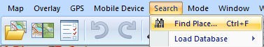
- Search by place name
From the tool bar, choose Search > Find Place:
The following screen will appear: Type in the required place name, in this case 'Roeux', or enter the Latitude/Longitude in the lower box.
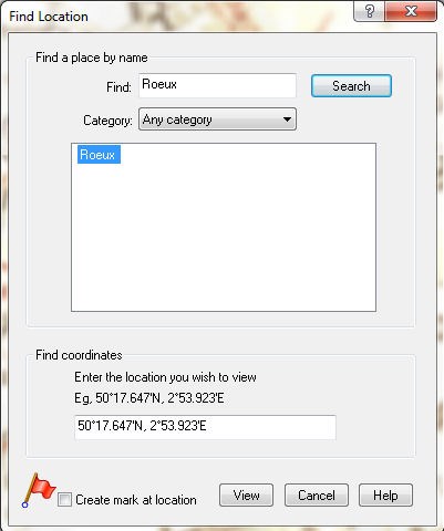
If you now press View the system will centre on the location chosen. Don't forget that many French place names are duplicated so try all the options presented.
This index has been produced for LinesMan Western Front 1:10,000 and does not cover the extended areas included in LinesMan Western Front 1:20,000. This index of place names includes cities, towns and villages and does not include smaller locations such as hamlets and farms.
If your first request produces no result check the spelling and re-try as necessary. If there is still no result your specific location may not be included in the index as explained above.
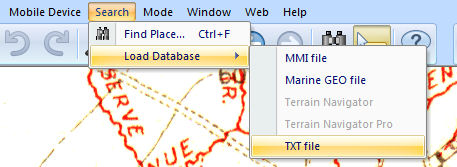
Click the drop down menu at Any category and if no other category is listed then an index has not been loaded. Simply download 1914_18 WesternFront_index (right click and choose 'save link as' or 'save target as') to your PC/laptop. This is a .txt file and from the Memory-Map browser click Search>Load Database>TXT file.
Select the storage location for 1914_18 WesternFront_index on your PC/laptop and click Open. The index will now be loaded and you can proceed as above Search>Find Place
b) Search for the map by reference, or by name.
First press the LinesMan map list folder icon on the toolbar. The following dialog box appears containing a map list
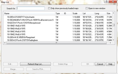
If you click above the map list, where it says 'Name', the list will sort into alphabetical order, and can be searched by scrolling down using the slider on the right hand side.
Alternatively, in the box at the top, labelled 'Search for:' type in any part of the map number or name that you know.
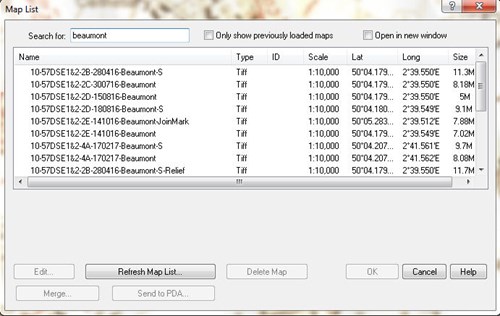
For example, typing in 'Beaumont', limits the list to all entries that contain Beaumont.
A typical Trench map has the following type of reference number:
10-57DSE1&2-4A-170217-Beaumont-S
This represents:
Scale (1:10,000)-Sheet Reference- Edition- Date of Correction- Map name- Secret Edition
(The date of this map is the 17th of February 1917 or 170217)
Note: the Secret versions show British trenches as well as German.
If the map name is suffixed by -Relief, then it is a Great War Digital unique Relief map, made by us from the original trench map. You will also find the unmodified map is available.
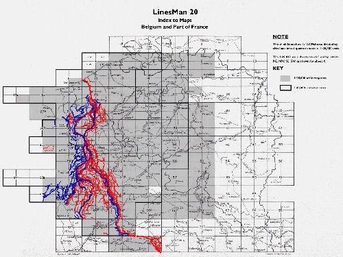
Alternatively, the map required can be located by referral to the LinesMan10 Map Key or LinesMan 20 Map Key, which can be found by right clicking anywhere on the front line area and choosing the appropriate Map Key option, or by selection from the map list. For most maps there are multiple editions available.
The vector overlays, unique to LinesMan, are clearly visible overlaid on the map keys.
Choose the square that interests you. Simply Right click on the spot, giving you the following dialogue:
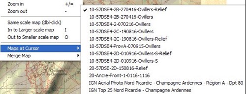
Now choose the map you require. The map currently being displayed is marked with a tick. Note that maps at 1:10,000 scale and 1:20,000 scale are listed.
Information regarding 'Maps at Cursor'
The combination of LinesMan 10 and LinesMan 20 offers the opportunity to study the largest collection of British mapping of the period published since the Great War itself.
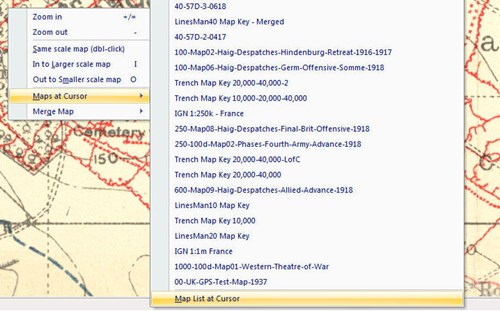
If Linesman 10 and 20 are loaded together the choice of maps at any point is now so extensive that at some places the mouse 'right-click'>Maps at Cursor feature may not be able to list all the maps currently available. To ensure you can review all maps at a particular position please 'right-click' your mouse and select Maps at Cursor>Map List at Cursor whereupon you may select a map from all those available to display.
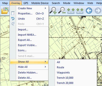
c) Turning on and off the vector Trench Layer.
All the major trenches have been converted to vectors (electronic lines). Any Trench Map that shows a section of front line trench, with no-mans land in between has been copied with a thick Blue line for British and a thick Red line for German. In addition, any significant lines of support have been copied using a thinner line. The purpose is to allow the overlays to be viewed over the modern IGN, or aerial photography, and in order to help you familiarise yourself with the main battle locations.
We have added a set of vector lines shown on the 1:10,000 scale maps and a set for the ones shown on the 1:20,000 scale, and these can be turned on and off independently.
For example choose: Overlay, Show All, Trench 10,000 or Overlay, Hide All, Trench 10,000 to toggle on and off.
d) Turning on and off the Map Outlines.
The map outlines are shown in very fine green lines (below), or blue lines for the IGN regions. These can be toggled on and off by choosing: Map, Show Map Outlines.
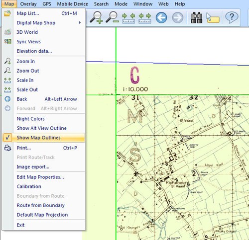
This may be important when you wish to print.
e) Sending Maps to a handheld GPS device
If using one of the devices from the Adventurer range then familiarise yourself with the relevant Memory-Map User Guide.
For iphone/ipad users see details of the paid app.
Although PDA devices are less common now, this is very easy once you are a little familiar with the PDA device that you own.
Simply, all PDA devices will connect to your PC in order to be backed up against data loss if the battery goes flat. The program normally used is Microsoft Active Sync. This backs up your PDA automatically every time it is connected via a cable.
To use the PDA with LinesMan first connect the PDA as per the instructions using MS Active Sync.
Then choose the map or screen shot in Memory-map that you wish to send to the device. Now choose
Mobile Device, Send Map, or Send Visible Map Portion
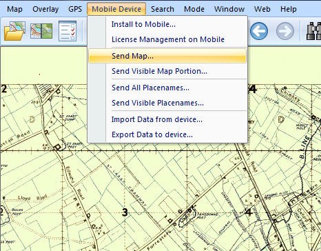
This will send the required map to the handheld GPS device, if possible store the maps on a suitable SD card.*
These copied maps will then function with GPS. They are not, however, interchangeable with other Memory-Map products.
You will see on the options above, the option: Mobile Device, Install Pocket Navigator.*
This is for PDA users. Prior to transferring maps for the first time you will need to install Pocket Navigator onto your PDA by choosing this option and following the on screen instructions.
Please note, whichever handheld device you are using you will need to ‘Activate' the trench maps, GPS functionality and any new SD card. Please do so in accordance with the instruction leaflet supplied with LinesMan and/or the device/app concerned.
*Pocket Navigator is pre-loaded on the Adventurer range of GPS devices and for the iphone/ipad map transfer is only available via a wi-fi system